Something else that seems quite profound is that the green space adjacent to the Brewery was mentioned as somewhere that the youth club would like to use for events, barbecues and so forth in the warmer weather. However this cannot happen because of health and safety reasons.
There is an opportunity here to work toward a better external community space, that can be used for such events. The phrase 'children lining the street on Mayday' springs to mind as something to be reinterpreted through this greenspace that runs a considerable length along Cambridge Street.
There is an opportunity for these much needed activities to inform the development of spaces and vice versa. Dialogue is needed to make these sorts of needed changes happen. Even for the right for the youth club to able to initially use these spaces temporarily without risk.
Thursday, 12 February 2009
Friday, 30 January 2009
Mapping the Area
Inital engagement with Springfield Youth Club has provided some interesting information. Through informal interviews, youth club members were asked to begin the map their routes, experiences and thoughts on a plan of the area.
Questions were asked such as; "what is special about the area? ", "what would you put on a postcard of the area?" and "if you could change something, what would it be?" However this was mostly an information exercise to see how they used the public areas, routes and paths, and why they chose to do so.
What has arisen so far begins to reveal why the area can be seemingly quiet. Although there is a lot of activity within the walls of the community centre, members said they hardly ever used the canal towpath and sometimes even caught the bus the short distance into town. It also emerged that the inability to use public spaces for events and activity had an impact on their interaction and engagement with the place. For example the Butler's sign wasn't at the forefront of their minds when asked to state a landmark. Much different to what I would say.
Answers (so far) span from "the Premier Inn" to "the butchers". The reason for the latter was that it is a remaining shop with distinct specific character. It seems the former answer may be questionable as a 'landmark' if the term is used to describe something that helps you to identify with an area in more ways than just spatially. Perhaps this describes a great deal about the change in urban landscape and attitudes. Also the back route to the train station featured as an interesting route often taken. However the direct route to Broad street was also taken, not simply because it was direct, but "because of the cars".
This puzzled me at first, until it became clear that this was an issue of passive surveillance. The railway bridge route recieved some derogatory comments, therefore initially I wondered why this was a prefered route. The presence and activity of cars proved to be an safer environment and this was coupled with an answer of "because of the lights" - in other words, headlights illuminating the passage beneath the bridge.
Another route previously taken involved steps to the rear of the new student acommodation development and under the railway, which now ceases to exist. The steps were the first thing mentioned as something that they rememered as an interesting and familiar route.
There were very few meeting places mentioned, no areas where any sort of activity took place, members often meeting in town by sight along Broad Street. Perhaps this is a transitory culture that skims the surface of the place. Those 'ways in' to engaging place often missed as they do not feature on a safe or desired route.
On the whole it became evident that activity needs to be allowed to move from the private to the public realm. This could simply mean an external ball court area, or simple lighting to provoke changes.
Wednesday, 26 November 2008
An Embarrassment of Riches
I recently met with archaeologist Mike Shaw at Wolverhampton City Council to discuss the Canalside Quarter (see https://www.wolverhampton.gov.uk/NR/rdonlyres/DE1A2400-4384-482A-A72C-A4D96C7FF94D/0/2_background.pdf )
Obtaining a copy of archaeological assessment , I found that within or adjacent to the assessment area lies a plethora of sites and monuments recorded. ( I just looked up the word ‘plethora’ and found a definition as an ‘embarrassment of riches’.)
Horseley Field ( the word horseley derived from horselowe, indicative of a low burial mound) which was a probably a later route, runs roughly east to west.
407 Entrance features, Springfield Brewery
540 16A Union Mill Street
571 Retaining wall to High Level line, Lock Street
572 High Level Railway Bridge, Wednesfield Road
573 High Level Railway Bridge, Lock Street
1651 House (site) approx. 15m W of Union Mill, Union Mill Street
1652 Fo Cheese & Butter Warehouse, Union Mill Street
1713 Albion Mill, Albion Street
2503 Horselowe Barrow
2567 Cul Well
2579 Victoria Basin, (No. 1 Lock, Little’s Lane Bridge)
2582 Low Level Station
2583 Railway Arcade, High Level Station
2590 Edmund Vaughan Stampings/Griffin Works, Horseley Fields
2594 Springfield Brewery
2597 Old Steam Mill (Millers Mil), Corn Hill
2598 Union Mill (remains), Union Mill Street
2873 Cobbled Road, Horseley Fields
5853 Birmingham Canal
5858 Wyrley & Essington Canal
5884 Shrewsbury & Birmingham Railway
5886 Oxford Worcester & Wolverhampton Railway
5887 Birmingham Wolverhampton & Dudley Railway
6746 Great Weston Public House, Corn Hill
6748 Top Lock Cottages, 109-110 Little’s Lane
6778 Mill Street Railway Goods Depot, Corn Hill
6887 No. 2 Lock, Birmingham Canal
6888 No. 3 Lock, Birmingham Canal
6889 No. 4 Lock, Birmingham Canal
6890 No. 5 Lock, Birmingham Canal
6908 12-13 Corn Hill (site)
6914 Mill Street Bridge, Birmingham Canal
6922 Railway Engine Shed, Corn Hill
6923 Railway Bridge, Corn Hil
6924 Office, Broad Street Wharf, Birmingham Canal
6925 Clinker Wall, Birmingham Canal
6928 Railway Footbridge, E of Low Level Station
6929 Tunnel Portal, E of Crane Street Junction
6992 Canal Tunnel, bnth High Level Station Approach, Railway Drive
6993 High Level Station (site
6994 Broad Street Wharf, Birmingham Canal, S of Wednesfield Road
6995 Herbert Street Goods Depot (Victoria Basin), Western Street
8506 Canal basins, W & E Canal, Horseley Fields Junction
8512 Wolverhampton Temporary Station (site) N of Wednesfield Road
9918 Admin Number, Springfield Brewery Development Survey Area
9919 Methodist Chapel (site) Culwell Street
9920 Wesleyan Chapel (site) Grimstone Street
9951 Cannock Road Wharf
10050 Gas Works, Horseley Fields
10636 Sparrows Ironworks, N of W & E Canal
10637 Shakespeare Foundary
10663 Swan Garden Ironworks, betw Swan Street & Colliery Road
10678 Culwell Foundry (site) S side Little’s Lane
10679 Albion Ironworks
10680 Crane Foundry, betw Bham Canal & Railway, Horseley Fields
10723 Towpath Bridge & Road Bridge, W & E Canal, Horseley Fields Junction
10724 Horseley Fields Canal Bridge, LNWR Railway
10741 Horseley Fields Bridge, Lower Horseley Fields
10742 Broad Street Bridge, Broad Street/Wednesfield Road
10743 No. 1 (Top) Lock, Bham Canal
10744 Little’Lane Bridge, Lock Street
10745 Railway Bridge, N of No. 3 Lock, Bham Canal
10746 Cannock Road Bridge, Cannock Road
10800 Admin Number, area W of Canal
10934 Old Line, Birmingham Canal
10935 Workhouse, Wolverhampton
10936 10-11 Grimstone Street
10937 Junction area of Bham Canal and W & E Canal
10938 CanalBasin, SW of No. 4 Lock, Bham Canal
10939 Canal Cottages, E side of No. 4 Lock, Bham Canal
10940 Quarries, Grimstone Road Area
10941 Zion Chapel (site), N side of Horseley Fields
10942 Buildings betw Cannock Road, railway & canal
10943 Building betw canal & railway, N side Wednesfield Road
10944 Mission Room (site), Victoria Basin, Bham Canal
10945 Buildings, N of Little’s Lane betw canal & Victoria Basin
10946 St. Mary’s Church etc (site), Stafford Street
10947 Gladstone Bicycle Works (site), Stafford Street
10948 Great Western Brewery (site), Great Western Street
10949 Lock Factory (site), Stafford Street
10960 Admin Number for the Canalside Project
10961 Horseley Fields Chemical Works (Bailey’s)
10997 Hay (Albert) Basin, E of Top Lock
11001 Victoria Basin Bridge, Birmingham Canal
11002 Horseley Fields Junction Road Bridge, Ex LNWR Railway
11003 High Level Station Approach (S) Ex LNWR Railway
11004 Crand St Junction Railway Tunnel, Ex LNWR Railway
11005 Wednesfield Road Bridge, Ex LNWR Railway
11006 Culwell Street Footbridge, Ex GWR
11007 Cannock Road Bridge, Ex GWR
11008 Old Steam Mill Annexe, Corn Hll
11009 Springfield Brewery, Buildings, S of Cambridge Street Gate
11010 Springfield Brewery, Buildings, N of Cambridge Street Gate
11011 Springfield Brewery, Building on Grimstone Street
11012 Springfield Brewery, Office Building on Grimstone Street
11013 Springfield Brewery, Building & Chimney, North End
11014 Springfield Brewery, Boundary Wall etc. Cambridge Street
11015 Springfield Brewery, Western boundary wall
11016 Gateway of Station approach ex LNWR Railway
11017 1-14 Faulkland Crescent
11018 Bridges over Three Basins, Wyrley & Essington Canal
11019 Horseley Fields Junction Stoplock Wyrley & Essington Canal
Tuesday, 25 November 2008
Mapping Your Wolverhampton
Meeting with Amanda Bevan ( Neighbourhood Coordinator) at Heath Town Community Centre, we shared ideas on how individuals could 'map' their own everyday routes and therefore experiences and memories of this area. In this way we thought it useful to find out answers to simple questions such as 'what goes on here? and what routes do people take and why? What do people notice about this area changing?
This is important on a variety of levels to understand how the canal corridor is used, as well as roads such as Sun Street and what the terms 'landmark' or 'meeting place' means here. Its also important to see how people get to and from the city centre.
A resource has been distributed in the hope that this can build a picture of the area; its uses past and present and how this can merge together harmoniously. Perhaps then by undertaking a route, your experiences could naturally let you engage with the place and its identity.
Walk around this place and don't read any signs. How do you know you are in Wolverhampton?
Ask yourself what this area is known for? What this place is all about..what goes on here? It's not just what stories in the Express and Star tell us, and it is not going to make itself apparent from blank grey cladded structures or a choice of construction materials that echo an industrial past.
It's everything that has been, what goes on now and what will go on. How we use this place and experience it in our daily lives. Wolverhampton has to authentically be itself, not compete or relate to anywhere else. It is how best we are able to embed, keep and allow ways to experience authenticity throughout the changes that is important.
Friday, 17 October 2008
To the Station and to the City Centre
 Passages to the train and bus stations from the Wednesfield Road,
Sun Street and the Corn Mill, accessing the canal. Artist involement at the Corn Mill site?
Walking under riveted beams of the rail bridge over the Wednesfield Road, I noticed the 113 plaque and then around to the arched passageway, with wrought ironwork and white tiled walls with ghosted graffitti , then over worn pavings that looked like large flat cobbles and up to the train station, opening out to the familiar sight of the multi storey car park with its dark red lines connecting floors and then down to matching bollards. through the fence I saw the unmistakeable sign of 'Fellows Morton and Clayton' on the back face of the British Waterways Depot.
Walking up toward the bus station and over the Ring Road St. Davids I forgot that the bridge overran the canal and I got to familiar blue railings. I tried to make it down here to the canal, but couldn't. I took a photo and reminded myself of this by a shadow cast by the bright sun of the railings down to the towpath at about a forty five degree angle. This made me realise that where I felt I wanted to gain access to, or where it seemed logical to walk, I couldn't. The canal here could be an interesting entrance and exit point to the stations and the future interchange. Again this area is very restrictive in pedestrian flow and the opportunities here seem to be great and exciting.
I retraced my steps and to my original starting point and wondered how far it is to the nearest obvious access to the canal. Perhaps I should count my paces next time, though I believe it was quite a lot.
I decided then to walk down Sun Street. Whether it is the name 'Sun Street I don't know, but there is something interesting about this street , shaped like a giant 'W' on a street plan.
On arriving upon the Great Western pub and with the Low Level Station to my left I began to realise the importance of Sun Street as a linking road to the city centre. I noticed an intermittent stream of pedestrians alongside the arch patterned blue brick railway wall toward the Wednesfield road. Continuing under the bridge, up the cobbled street, I got an overwhelming sense of an important period in industriality totally specific to Wolverhampton. Then, before me was the burnt out Corn Mill. I was reminded of Councillor Neville Patten's comments in the Express and Star; “it’s a great loss to the city as the building was associated with Wolverhampton’s industrial heritage. It remains to be seen what the developers will be able to do now. Perhaps the building can still be salvaged or it may have to be demolished completely.”
I'm not aware of what is happening to the mill, but perhaps artist involvent can help to maintain a sense of this place if the building is demolished in whatever capacity. This wormhole view of Wolverhampton's identity cannot be lost.
On my return I noticed a square of concrete marked with a date, filling in a gap in the bridge, that cracks slightly to monitor its movement. It was telling me that this landscape is breathing and that the aim shouldn't be to suffocate it or deny it sympathy.
Tuesday, 30 September 2008
Bridging Connections
 An initial investigation of Broad Street Basin and bridge, the intersection of rail, road and canal. Linkages and ways in.
The relationships between rail road and canal in this area brought me to a crucial point, the Broad Street Basin. There is curious mix here of traditional canal activities, the Canal nightclub in the Broad Street Depot and the railway bridge that cuts off the old route of Broad Street into the Wednesfield Road. The Canal, Rail and Ring Road serve as divisions to what is beyond. Perhaps this is due to the removal of the old bridge ( pictured) in the 1970's to the rather generic functional one there now, the same sort of languid bridge design that has prolifereated along our canal system. Perhaps that is why after we pass under this bridge and move toward the station and Horseley Fields, Cambridge Cyclist Campaign earmark it as 'worth avoiding'.
Of course small remaining details become illuminated through the imagination, although you have to work hard past other elements, rather than those elements working together harmoniously. Engaging with this landscape , it is difficult to percieve that sense of specific identity that emerges through, for example, walking along the brewery wall. What is undeniably certain is that this place marks the start of an area intimately connected with the canal and its industries and the lifestyles associated with that.
I'm going back to the story of Bill Lloyd carrying his first bottles of 'smackers' back from the brewery on his first day, along the canal on his bike, or Dennis Groves walking into town after a Saturday morning's work, or even activities such as the May Day parade in Cambridge Street. There was an environment that encourages this activity. Derek Wiggins told me of 'Courtyard Back' housing and walking past washing lines dripping with clothes; that the walk home was full of rich activities that augment the particular experience of this place and set firm memories . I wonder about the same enthusiasm and fondness guilding a conversation of the place today.
What is lacking now is that overt sense of activity and those interconnected detailed experiences of navigating through these passages to and from the Springfield area.
I am aware planned changes are beneficial , but there are further opportunities. The invisible wall created by the railway bridge , canal and ring road on the outskirts of the City Centre could be turned upside down, so that this area becomes synonymous with interconnecting movement and the 'darkness' of the Broad Street Basin turned to 'light'. The intended changes to routes and passageways for cyclists and pedestrians canbe informed to illuminate subtle clues to Wolverhampton's rich identity though the experience of travelling these paths.
The old bridge is now at the Black Country Museum. There may have been structural reasons for its removal, but this is exactly what the place is missing. A route over bridge gave us that insight into how to percieve the landscape, it embodied the sensibilities of Wolverhampton - as we saw it approaching, travelled over it, leaned on it, looked over into the canal on the way to the Union Inn, our activities became intertwined with the place and with the bridge itself. The materials it is made with, its form, colour and possibly the sound it may have made as we travelled over it, allowed us to step within the 'grain' of Wolverhampton and engage with it through recognising the industrial traditions and historical activities intimately tied to this minor place. It was one way in.
Of course we are not coming back from, or going to work from the Brewery, Culwell Foundry, the Steam or Corn Mill. However on those journeys to and from the city centre, to the Interchange, to Springfield and so on, we can go about out daily lives by choosing to enjoy and engage with the city and it rich, complex layers. We can choose to create new ways in. Those new routes can perform and function as the minor route over the bridge did, not simply as something that stops us falling in the water, or something that gets us from A to B in the quickest time possible. Painting and paving can involve so much more.
Within the fabric of these physical connections are other connections and bridges between how we use, how we percieve and how we place ourselves within the city. It is how we connect up those current hidden activities and desires of people in the area to the changing landscape and bring those attributes harmoniously to the surface.
Friday, 26 September 2008
Inter - change
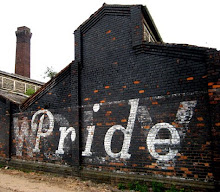
On Entering Wolverhampton. Views, Vistas and the 'Pride of the Midlands'.
On the way to Manchester on the train recently, I looked over toward Springfield. Although the Brewery site remains mostly in stasis with only minor changes happening, activity on the adjacent site was very much underway for the new student accomodation buildings. With the Low Level Station development and the nearby new Interchange, these factors are changing the area, the activities that arise here and how they are linked to the urban landscape.
I've begun to see the importance of this area in relation to entering and exiting Wolverhampton. I'm imagining that workers delivering goods travelling to the brewery, along the rail spur that entered the site, would associate the landscape here with the wider area of Wolverhampton. The activities that would go on here, the characteristic lettering on the wall, signage and so on is very much linked to the passing of trains and narrow boats. These two elements of the canal and rail that follow each other, become very apparent and intertwine here right near the heart of the city.
The views from up high, greeting you as you enter the city are just as important as the activities on the ground. There must be an opportunity here to connect these together through new developments. Almost as if seeing 'PRIDE' on the wall at the Brewery can represent this area again, by how the landscape and its diversely related activities can weld together at this point through acknowledging and reinterpreting the past ethos of the area.
With the new Interchange development hitting the edge of Springfield, the canal corridor and rail, there's opportunities of access points to the canal from the town and vice versa, that will enable activity to penetrate this area, rather than a invisible border that cuts the city centre off at this point.
The question is, how these new developments become realised and contribute to a meaningful place, by being informed by that industrial and social identity that runs through the grain of the city. That sense of 'PRIDE' can only come through recognising the importance of the historical landscape and its past and present related activities, that can allow us to feel part of the story of the city without losing what is so strongly specific about it.
www.wolverhamptoninterchange.co.uk
Subscribe to:
Posts (Atom)


+copy.jpg)
