I recently met with archaeologist Mike Shaw at Wolverhampton City Council to discuss the Canalside Quarter (see https://www.wolverhampton.gov.uk/NR/rdonlyres/DE1A2400-4384-482A-A72C-A4D96C7FF94D/0/2_background.pdf )
Obtaining a copy of archaeological assessment , I found that within or adjacent to the assessment area lies a plethora of sites and monuments recorded. ( I just looked up the word ‘plethora’ and found a definition as an ‘embarrassment of riches’.)
Horseley Field ( the word horseley derived from horselowe, indicative of a low burial mound) which was a probably a later route, runs roughly east to west.
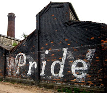
407 Entrance features, Springfield Brewery
540 16A Union Mill Street
571 Retaining wall to High Level line, Lock Street
572 High Level Railway Bridge, Wednesfield Road
573 High Level Railway Bridge, Lock Street
1651 House (site) approx. 15m W of Union Mill, Union Mill Street
1652 Fo Cheese & Butter Warehouse, Union Mill Street
1713 Albion Mill, Albion Street
2503 Horselowe Barrow
2567 Cul Well
2579 Victoria Basin, (No. 1 Lock, Little’s Lane Bridge)
2582 Low Level Station
2583 Railway Arcade, High Level Station
2590 Edmund Vaughan Stampings/Griffin Works, Horseley Fields
2594 Springfield Brewery
2597 Old Steam Mill (Millers Mil), Corn Hill
2598 Union Mill (remains), Union Mill Street
2873 Cobbled Road, Horseley Fields
5853 Birmingham Canal
5858 Wyrley & Essington Canal
5884 Shrewsbury & Birmingham Railway
5886 Oxford Worcester & Wolverhampton Railway
5887 Birmingham Wolverhampton & Dudley Railway
6746 Great Weston Public House, Corn Hill
6748 Top Lock Cottages, 109-110 Little’s Lane
6778 Mill Street Railway Goods Depot, Corn Hill
6887 No. 2 Lock, Birmingham Canal
6888 No. 3 Lock, Birmingham Canal
6889 No. 4 Lock, Birmingham Canal
6890 No. 5 Lock, Birmingham Canal
6908 12-13 Corn Hill (site)
6914 Mill Street Bridge, Birmingham Canal
6922 Railway Engine Shed, Corn Hill
6923 Railway Bridge, Corn Hil
6924 Office, Broad Street Wharf, Birmingham Canal
6925 Clinker Wall, Birmingham Canal
6928 Railway Footbridge, E of Low Level Station
6929 Tunnel Portal, E of Crane Street Junction
6992 Canal Tunnel, bnth High Level Station Approach, Railway Drive
6993 High Level Station (site
6994 Broad Street Wharf, Birmingham Canal, S of Wednesfield Road
6995 Herbert Street Goods Depot (Victoria Basin), Western Street
8506 Canal basins, W & E Canal, Horseley Fields Junction
8512 Wolverhampton Temporary Station (site) N of Wednesfield Road
9918 Admin Number, Springfield Brewery Development Survey Area
9919 Methodist Chapel (site) Culwell Street
9920 Wesleyan Chapel (site) Grimstone Street
9951 Cannock Road Wharf
10050 Gas Works, Horseley Fields
10636 Sparrows Ironworks, N of W & E Canal
10637 Shakespeare Foundary
10663 Swan Garden Ironworks, betw Swan Street & Colliery Road
10678 Culwell Foundry (site) S side Little’s Lane
10679 Albion Ironworks
10680 Crane Foundry, betw Bham Canal & Railway, Horseley Fields
10723 Towpath Bridge & Road Bridge, W & E Canal, Horseley Fields Junction
10724 Horseley Fields Canal Bridge, LNWR Railway
10741 Horseley Fields Bridge, Lower Horseley Fields
10742 Broad Street Bridge, Broad Street/Wednesfield Road
10743 No. 1 (Top) Lock, Bham Canal
10744 Little’Lane Bridge, Lock Street
10745 Railway Bridge, N of No. 3 Lock, Bham Canal
10746 Cannock Road Bridge, Cannock Road
10800 Admin Number, area W of Canal
10934 Old Line, Birmingham Canal
10935 Workhouse, Wolverhampton
10936 10-11 Grimstone Street
10937 Junction area of Bham Canal and W & E Canal
10938 CanalBasin, SW of No. 4 Lock, Bham Canal
10939 Canal Cottages, E side of No. 4 Lock, Bham Canal
10940 Quarries, Grimstone Road Area
10941 Zion Chapel (site), N side of Horseley Fields
10942 Buildings betw Cannock Road, railway & canal
10943 Building betw canal & railway, N side Wednesfield Road
10944 Mission Room (site), Victoria Basin, Bham Canal
10945 Buildings, N of Little’s Lane betw canal & Victoria Basin
10946 St. Mary’s Church etc (site), Stafford Street
10947 Gladstone Bicycle Works (site), Stafford Street
10948 Great Western Brewery (site), Great Western Street
10949 Lock Factory (site), Stafford Street
10960 Admin Number for the Canalside Project
10961 Horseley Fields Chemical Works (Bailey’s)
10997 Hay (Albert) Basin, E of Top Lock
11001 Victoria Basin Bridge, Birmingham Canal
11002 Horseley Fields Junction Road Bridge, Ex LNWR Railway
11003 High Level Station Approach (S) Ex LNWR Railway
11004 Crand St Junction Railway Tunnel, Ex LNWR Railway
11005 Wednesfield Road Bridge, Ex LNWR Railway
11006 Culwell Street Footbridge, Ex GWR
11007 Cannock Road Bridge, Ex GWR
11008 Old Steam Mill Annexe, Corn Hll
11009 Springfield Brewery, Buildings, S of Cambridge Street Gate
11010 Springfield Brewery, Buildings, N of Cambridge Street Gate
11011 Springfield Brewery, Building on Grimstone Street
11012 Springfield Brewery, Office Building on Grimstone Street
11013 Springfield Brewery, Building & Chimney, North End
11014 Springfield Brewery, Boundary Wall etc. Cambridge Street
11015 Springfield Brewery, Western boundary wall
11016 Gateway of Station approach ex LNWR Railway
11017 1-14 Faulkland Crescent
11018 Bridges over Three Basins, Wyrley & Essington Canal
11019 Horseley Fields Junction Stoplock Wyrley & Essington Canal


+copy.jpg)
